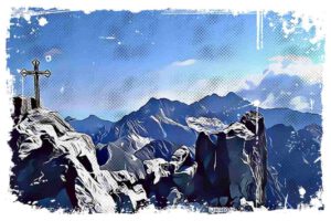
Have you ever heard about the peaks of Tatra Mountains? Tatras is a breathtaking mountain range with peaks spread within the borders of two countries – Poland and Slovakia. Covering a total area of 785 km2, these mountains are a must-see, even though only a small part of them (175 km2) is in Poland. Trust me, there’s no shortage of high peaks worth climbing and many other places worth visiting in the Polish part of the Tatra Mountains.

With over 1,000 peaks in the entire Tatra Mountains, you’ll have plenty of options to choose from. Let me say, about 100 of these peaks can be accessed along marked hiking trails. Many of the Tatra hills have a very similar height, but the best-known and highest ones are classified in the Great Crown of the Tatra Mountains.
This list includes the 14 highest peaks in the Tatras, and I know that reaching them is the goal of most experienced mountaineers. However, it’s not so easy to get to the highest peaks of the Tatras, and for this reason, the Tourist Crown of the Tatras was created. This one has as many as 60 peaks, which will be fully achievable for virtually every lover of mountain trips.
The Tatra Mountains Peaks – Poland and Slovakia’s Summits
As I mentioned earlier, the Tatra Mountains are the highest mountain range lying in two countries – Poland and Slovakia. Within the borders of Poland, there are 175 km2 of the Tatra mountain chain, while on the Slovak side, there’s an area of 600 km2.
↳ Before you head to Tatra Park, I highly recommend reading my complete guide to Tatra Mountains. I showcase the most scenic places you won't want to miss. Make sure to check it out, so you don't overlook anything interesting: Tatra Mountains – An Insider’s Guide to All Attractions and Info
I believe it’s worth mentioning that even though the Tatra Mountains are neither the highest mountains in the world nor in Europe, they still attract large numbers of climbing enthusiasts every year.
In case you’re wondering, the Tatra National Park has been established in the Tatra Mountains, and it belongs to the UNESCO World Network of Biosphere Reserves. I think it’s important to note that the high-mountainous part of the Tatras has a glacial character and, in this respect, is unique on a national scale.
Different Parts of the Tatra Mountains
Did you know that the Tatras are divided into four ethnographic regions? Let me introduce you to Podhale, Spisz, Orawa, and Liptov. Within these regions, there are three separate mountain ranges – the Western Tatras, the High Tatras, and the Belianske Tatras. Each of them is unique and worth seeing. If you’re looking for the most interesting places, I think you should check out: The Most Scenic Places to Stay in Polish and Slovak Tatra Mountains
The highest peak of the Western Tatras is Bystra (2,248 m above sea level, located on the Slovak side), and Starorobociański Wierch (2,176 m above sea level, located in the Polish part of the Tatra Mountains).
The highest peak of the High Tatras is Gerlach, with a height of 2,655 m above sea level (a border peak belonging to Slovakia), and the north-western peak of Rysy with a height of 2,499 m above sea level.
There’s also a geographical division into the Polish Tatras and the Slovak Tatras. The Tatras map published in 2018 divides the Polish Tatras into Reglowe Tatras with the highest peak Mała Kopa Królowa (1,577 m), the Western Tatras, and the High Tatras.
The History of Tatra Tourism
The Tatras are the most majestic mountains in Poland, so it’s no surprise that they’ve been attracting crowds of tourists seeking mountain experiences for centuries. Tourist traffic in the Tatras began on the southern side.
According to historical data, the first trip to the Tatra Mountains was on June 11, 1565, during Pentecost. It was then that the wife of the then Count of Spiš, Beata Łaska went for a ride from Kieżmark to Zielony Staw Kieżmarski. This was the first expedition to the Tatra Mountains recorded in historical sources.

In the 17th century, the first mentions of ascents to the peaks of the Tatra Mountains appear. In 1615, David Frolich was supposed to climb the Kieżmarski Peak, while in 1664 Georg Buchholtz senior climbed Sławkowski Peak for the first time. Later, he published several works on the history and nature of the Tatras and Spisz, which were well-received among the researchers of the region at that time.
In 1683, the book „Ungarischer oder Dacianischer Simplicissimus„ was published, most likely by a Wroclaw resident, Daniel Spier. The first accurate map of the Tatra Mountains was made in Austria in 1782, and several years after its development, other books descrbing the mountains were published.
Stanisław Staszic – The Father of Tatras
This region has attracted the interest of researchers not only from Poland but also from neighboring countries. The father of Polish Tatra tourism is considered to be Stanisław Staszic, who made numerous hikes in the Tatra Mountains from 1803 to 1805, combined with scientific research of these areas. His work, „O ziemiorództwie Karpatów i innych gór i równin Polski„, was published in 1815. Stanisław Staszic was also the first to climb Kołowy Szczyt – a hill with a height of 2,419 m
The Great Crown of the Tatras – 14 Tatra Peaks called „Eight-Thousanders”
Did you know that there’s a list called the Great Crown of the Tatras, featuring the highest peaks of the Tatra Mountains? Modeled after the Crown of the Himalayas and the Karakoram, both of these lists contain eight-thousanders. However, the Tatra Mountains’ highest peaks, in this case, are measured in feet not meters, like the Himalayas and Karakoram.
The Great Crown of the Tatras includes 14 peaks over 2,438.4 m above sea level, with at least 100 m above the pass separating them from the highest peak in their vicinity.
First published in the polish „Góry” magazine in 1998, the list and its criteria have been the subject of much debate. Some even considered them artificial and difficult to accept. Interestingly, peaks like Zadni Gerlach, Mały Durny Szczyt, or Lodowa Kopa didn’t make the list due to these criteria. The biggest „loser” was Mięguszowiecki Szczyt Wielki, which fell just a few centimeters short of the Great Crown of the Tatra Mountains at 2,438 meters (7,999 feet).
Despite the ongoing discussions, the 1998 criteria still stand today. The Great Crown of the Tatras features a unique mountain landscape, with all peaks located on the Slovak side. Janusz Chmielowski is considered the first to conquer the Great Crown of the Tatras.
Racing To The Peaks – Records
Over the last 20 years, racing to climb these peaks has become increasingly popular. In 2016, Paweł Oraniec climbed all 14 peaks in just 58 hours. His record was later broken by Alicja Paszczak, who reached the peaks in 49 hours. Today’s mountaineers face the challenge of breaking Kacper Tekiela’s 2020 record of 37 hours and 28 minutes.

Climbing the Great Crown of the Tatras typically starts from the east and moves west. The total elevation gain is 8,160 meters up and 7,914 meters down, with a total distance of 57.9 km. As you can see, conquering the Great Crown of the Tatras is a significant challenge for experienced mountaineers and not recommended for beginners.
Moreover, out of the 14 Tatra peaks on the list, only three (Rysy, Krywań, and Sławkowski Szczyt) have marked tourist trails. Other peaks, such as Lodowy Szczyt (2,630 m above sea level), Durny Szczyt (2,625 m above sea level), and Łomnica (2,634 m above sea level), can only be reached using mountaineering roads with the assistance of a Tatra guide.
Due to the high cost and challenges in reaching these peaks, an alternative list, the Tourist Crown of the Tatras, was created for those looking to conquer these majestic mountains.
60 Tatra Peaks and Passes Accessible to Everyone
For those who dream of symbolically reaching the highest peaks of Poland’s majestic mountains, the Tourist Crown of the Tatra Mountains is the perfect option. It includes 54 peaks accessible by marked hiking trails and 6 passes located near peaks without tourist trails. These peaks and passes can be found in both the Polish and Slovak sides of the Tatra Mountains.
The highest peak of the Tourist Crown of the Tatras is Rysy, which reaches 2,503 m above sea level on the Slovak side and 2,499 m above sea level in the Polish part of the Tatras. Following Rysy are Kriváň, a peak on the Slovak side at 2,494 m above sea level, and Sławkowski Szczyt (2,452 m), also in Slovakia.

The lowest peak of the Tourist Crown of the Tatras is located in the Polish part of the Tatras – Nosal, with a height of 1,206 m above sea level. The list also features passes, such as Lodowa Przełęcz (Ice Pass – 2,372 m above sea level), Red Bench (Czerwona Ławka) (2,352 m above sea level) on the Slovak side, and the Polish Przełęcz pod Chłopkiem (2,307 m above sea level).
The Tourist Crown of the Tatras includes peaks only in the Western Tatras and the High Tatras. There are no hills from the Belianske Tatras on the list. This is mainly due to the nature protection regulations in the Belianske Tatras area, where most regions are closed to tourist traffic.
Furthermore, there is no marked tourist trail to any of the peaks in the Belianske Tatras, which is a prerequisite for inclusion in the Tourist Crown of the Tatras.
The Highest Peaks of the Western Tatras in Poland and Slovakia
The Western Tatras are the largest mountain range in the entire Tatra Mountains in terms of the area they cover. The Polish-Slovak border runs through them. Historically, the Western Tatras were referred to by different names, such as Liptovské Haly, Liptovsko-Oravské, and Liptovsko-Novatarské Haly. The current name, „Western Tatras”, was adopted only in the second half of the 19th century.

The main ridge of the Western Tatras extends from Przełęcz Liliowe, which separates them from the High Tatras, to Huciańska Przełęcz, which separates the Western Tatras from Skoruszyńskie Wierchy. In the south, the border of the Western Tatras is marked by a significant fault that separates them from the Liptovská Basin.
On the Polish side, the border of the Western Tatras and the High Tatras is marked by the Gąsienicowa Valley and the Suchej Woda Gąsienicowa Valley. In addition to these, the Western Tatras also include the Mała Łąki Valley, Kościeliska Valley, Strążyska Valley, and perhaps the most famous in the entire Tatras, the Chochołowska Valley.

The main ridge of the Western Tatras stretches approximately 29 km in a straight line. The actual length of the entire mountain range is about 42 km. The Western Tatras cover a total area of 400 km², making up nearly 50% of the entire area of the Tatra Mountains. However, only 25% of their area is within the borders of Poland.
There are few lakes in the Western Tatras, with Niżni Staw Rohacki and Smereczyński Staw being the two largest. The Western Tatras are more gentle and beginner-friendly mountains than the High Tatras. Their landscape is characterized by domed peaks, numerous mountain valleys, and extensive ridges.
Bystra – The Highest Peak of the Western Tatras
Bystra is a peak situated in the Western Tatras on the Slovak side, and holds the title of the highest peak of the Western Tatras. It rises to an elevation of 2248 m above sea level above three beautiful valleys – Gaborowa, Kamienista, and Bystra. It is a keystone, meaning a point connecting three ridges, and the Bystre Ponds can be found under its southern walls.

Bystra is a peak composed of crystalline slates and interbeds of white granite. Interestingly, sheep used to graze on its slopes, reaching almost to the very summit of the mountain. Bystra is renowned for its spectacular avalanches, considered to be some of the largest and most awe-inspiring in the entire Tatra Mountains.
For years, Bystra has been a popular destination for mountain enthusiasts. No one can name its first conqueror, but the earliest known winter ascent was recorded at the beginning of the 20th century – it was accomplished by A. Świderska with a guide, Klimek Bachleda.
Before World War II, Bystra was a common tourist destination, with visitors climbing it during the day and at night, in part to admire sunrises and sunsets. The fascination with the highest peak of the Western Tatras is also evident in art – Bystra has been immortalized, among others, on the canvases of Jan Nepomucen Głowacki and Wojciech Gerson.

The view from Bystra is described as extraordinary, even delightful. Perhaps it is due to this that local highlanders referred to this hill as Pyszna, as well as the hall located just below its summit. Jerzy Mlodziejowski described the panorama from Bystra with these words:
„You would like to remember everything… Because the view from Bystra is so wonderful that it can move not only a geographer, but also an ordinary tourist”.
Adventurers who choose to stand atop Bystra will be able to see, for example, the soaring peaks of the High Tatras, including Świdnica and Krywań, the undulating accordion-like ridges of the Western Tatras, and the massive walls of Czerwony Wierchy and Kominiarski Wierch.
Tourist Trails Leading to Bystra
There are two marked hiking trails that lead to Bystra. The first is the yellow trail, which begins on the Tatra Road of Youth, located in Przybylin. It leads through the Bystra Valley all the way to the summit of Bystra, taking about 4 hours to complete.
The second tourist trail that will guide you to the highest peak of the Western Tatras is the blue trail. This trail runs along the southern slopes of the peaks in the main ridge, eventually transitioning into the green trail in the Gabrowa Valley.
The route along the green trail leads to Baniasta Przełęcz and continues along the slopes of Błyszcza to the summit of Bystra. The walking time for this trail is approximately 3 hours. Both hiking trails are open to tourists from June 15 to October 31.
Starorobociański Wierch – The Highest Peak in the Polish Part of the Western Tatras
Starorobociański Wierch (2176 m above sea level) is the highest peak of the Western Tatras on the Polish side and one of the highest elevations in the entire Western Tatras. It is situated in the main ridge of the Tatra Mountains, through which the Polish-Slovak border runs. It is separated from Kończyczy Wierch, to the west, by the Starorobociańska Przełęcz.

At its base, numerous valleys can be found – Starorobociańska, Zadnia Raczkowa, and Doborowa. The summit of Starorobociański Wierch is a short ridge which, like a wedge, squeezes into the Doborowa and Raczkowa Valleys.
The name of the peak originates from Hala Stara Robota, which was previously located in the Starorobociańska Valley. „Stara Robota” („Old Workplace”) simply meant closed excavations that remained in the area after the end of iron ore mining in the 16th century. Starorobociański Wierch is associated with numerous legends, one of which states that robbers hid valuable ducats in the place where the sun shines the earliest on St. Michael’s Day.

Starorobociański Wierch has a distinctive pyramid shape, and its slopes are stony. It is composed of metamorphic rocks and igneous granitoids. Heavy avalanches cascade down its steep slopes during the winter. Due to its central location in the Tatra Mountains, Starorobociański Wierch offers an excellent vantage point. From its summit, you can admire the panorama of the Western Tatras, the High Tatras, and the surrounding peaks – Bystra, Kamienista, Ciemniak, and Rohacze.
The Red Tourist Trail to Starorobociański Wierch
The red tourist trail leads to the highest peak of the Western Tatras on the Polish side. It follows the main ridge of the Tatra Mountains from Kończyty Wierch through Starorobociański Wierch and concludes at Liliowe Karbie.
The Highest Peaks of the High Tatras on the Slovak and Polish Sides
The High Tatras is the highest part of the Tatras, stretching between the Western Tatras and Belianske Tatras. Covering a total area of approximately 340 km2, with the larger portion (260 km2) located on the Slovak side, these mountains posess an alpine character.
The High Tatras stand out against the backdrop of the rest of the Tatra Mountains due to their soaring nature and distinct relief. The landscape of the High Tatras differs greatly from the Western Tatras, as the High Tatras are marked by towering crags, rocky peaks, and numerous beautiful lakes left by mountain glaciers.
The High Tatras are the highest mountains in both Poland and Slovakia and one of the highest mountain ranges between the Alps and the Caucasus. The highest peak of the High Tatras is Gerlach (2655 m), followed by Lominica (2634 m) and Lodowy Szczyt (2627 m). Other notable peaks in the High Tatras include Lamb’s Peak (2230 m above sea level) and Kozi Wierch (2291 m above sea level).
All the highest peaks of the High Tatras are situated within the borders of Slovakia. The highest peak of the High Tatras on the Polish side is Rysy, which is a border peak (2499 m above sea level on the Polish side and 2503 m above sea level on the Slovak side).
Numerous valleys can also be found in the High Tatras, such as The Valley of Five Polish Ponds, the Valley of Suchej Woda Gąsienicowa, and the Valley of Cold Water. The relief of the High Tatras shares features characteristic of the Alps’ relief. The mountain chain was formed as a result of the action of mountain glaciers during the Pleistocene glaciations.
Remnants of these events include circuses, glacial troughs, and the famous Tatra lakes, which attract large numbers of tourists to the High Tatras. The most renowned glacial lakes include Morskie Oko, Czarny Staw Gąsienicowy, and the lakes in the Valley of Five Polish Ponds.
Read More about Morskie Oko and the legend: A Guide to Visiting Morskie Oko, The Emerald Lake Near Zakopane
Gerlach – The Highest Peak of the Entire Tatra Mountains
Gerlach is the highest peak of the Tatras and the entire Carpathians. It is also the highest peak in Slovakia, which, due to its elevation, is included in both the Crown of Europe and the Great Crown of the Tatras. Gerlach forms a massif consisting of several peaks, the highest of which reaches 2,655 m above sea level.

There are no marked tourist trails leading to its summit, making it challenging to reach. Tourists most often ascend Gerlach from the Wielicka Valley or the Batyżowiecka Valley – however, the entrance is only possible under the care of a guide.
The first conquerors of the mountain were believed to be Spisz hunters who explored the area between the 18th and 19th centuries. The first recorded ascent on Gerlach took place in 1834 when Gelhof, Johann Still, and Martin Spitzkopf-Urban, residents of nearby towns, reached the summit during a chamois hunt. Gerlach was conquered again in 1855 by Zygmunt Bośniacki and Fr. Wojciech Grzegorek with the help of Tatra guides. The first tourist reached the summit in the 1860.
Rysy – The Highest Peak of the Polish High Tatras
Rysy is a mountain situated on the Polish-Slovak border. It has three peaks, with the highest being the middle peak, which rises to 2501 m above sea level and is located in Slovakia. The north-western peak, at 2,499 m above sea level, is the highest peak of the High Tatras in Poland. It is included in the Crown of Europe, which represents the highest peaks of all European countries.

Initially, it was thought that the name Rysy came from a diagonal gully within the mountain masif – Rysy in polish means scratch. However, it is now known to have originated from the grooved slopes of the entire complex of Niżnich Rysy, Żabi Szczyt Wyżni, and Żabi Mnich. This name was likely created by Polish highlanders and has been in use since the 19th century.
The Rysy massif is located south-east of Morskie Oko. At its base lie the Biała Woda Valley, the Rybi Potok Valley, and the Mięguszowiecka Valley. It is separated from Low Rysy by the Przełęcz pod Rysami, from Żabia Przełęcz, and from the Heavy Peak located in the High by the wide saddle of Libra.
In terms of nature, the Rysy Peak is a truly unique place in Poland. Its summit is covered with flowers from the group of alpine plants and numerous rare species, including Carpathian ukwap, Tatra meadow grass, and saxifrage, which are found in only a few places in the country. In terms of fauna, visitors to Rysy may encounter chamois, marmots, and foxes.
Ascending Rysy from the Shelter at Morskie Oko
Rysy is the most visited peak in the High Tatras. I was there once myself too. Its popularity is due to the stunning views from the summit, which offers a panorama of the Tatra Mountains with over 80 Tatra peaks, 13 lakes, and hills situated in other mountain ranges. In clear weather, visitors can see Kraków, about 90 km away, the outline of the Bieszczady Mountains, and even the Ukrainian Carpathians. I admit, it is amazing.

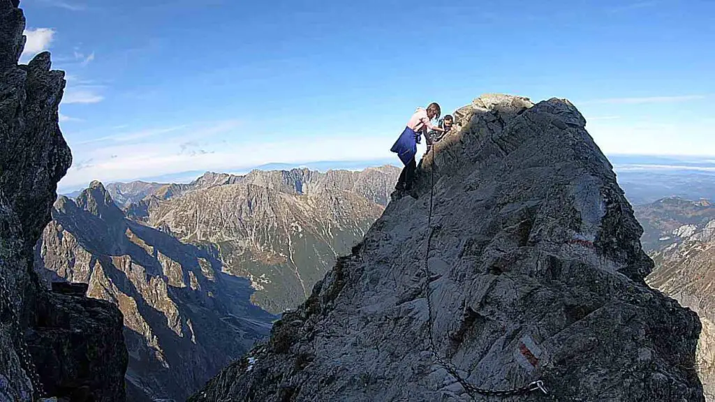
Rysy is the highest peak in the Tatra Mountains with a designated tourist trail. Its ascent is obligatory for those who collect the Crown of Polish Mountains, the Great Crown of the Tatras, the Crown of Europe, and the Tourist Crown of the Tatras. Two hiking trails lead to the summit – the northern one from the Polish side and the southern one from the Slovak side.
The northern trail is a red trail that starts at the shelter over Morskie Oko and leads to Czarny Staw, passing through Buła pod Rysami and continuing to the summit of Rysy. The trail goes around Morskie Oko and also traverses the surrounding passes. The most challenging section is just below the summit – the Pass under Rysy. At this point, there is a 500-meter abyss which is overcome by holding onto a chain and placing feet on narrow rock steps.
The Highest Peaks in the Belianske Tatras
The Belianske Tatras are situated entirely within the borders of Slovakia. These charming, idyllic mountains lie adjacent to the High Tatras, creating a picturesque landscape. The Belianske Tatras are low mountains, so it is impossible to find giants like Gerlach or Rysy here. Only five of their peaks exceed the magical limit of 2,000 m above sea level, with the highest, Havran, reaching 2,152 m above sea level.
It is worth noting that there are no hiking trails in the Belianske Tatras. The trails that existed in the past were closed between the 1970s and 1980s. Officially, this was due to the need to ensure appropriate natural protection for these areas. Unofficially, it was because of the presence of a government holiday center in Jaworzyna, where important personalities required silence, peace, and discretion.
Havran – the Highest, Inaccessible Peak of the Belianske Tatras
The highest peak of the Belianske Tatras is Havran. It rises to an altitude of 2,154 m above sea level in the middle of the western half of this mountain range. It is also the highest limestone peak in the entire Tatra Mountains. Havran towers over five valleys, and its slopes are home to interesting caves, including the Starzystarska Cave – the deepest cave in the Belianske Tatras. In ancient times, Havran was associated with the Weeping Rock and referred to as the Fork Peak. The etymology of the current name is unknown – it may stem from the Slovak word „havran”, meaning rook or gray horse.

The highest peak of the Belianske Tatras is believed to have been first climbed by Cyprian from the Red Monastery. Today, the easiest way to reach it is from the Zadnich Koperszady Valley, passing through Zadni Stefanowi Żleb and Hawrania Przełęcz. However, it is important to know that this area is under strict protection and closed to tourists. As a result, lovers of Tatra landscapes can only admire Havran from a distance.
Other Peaks and Passes in the Tatra Mountains
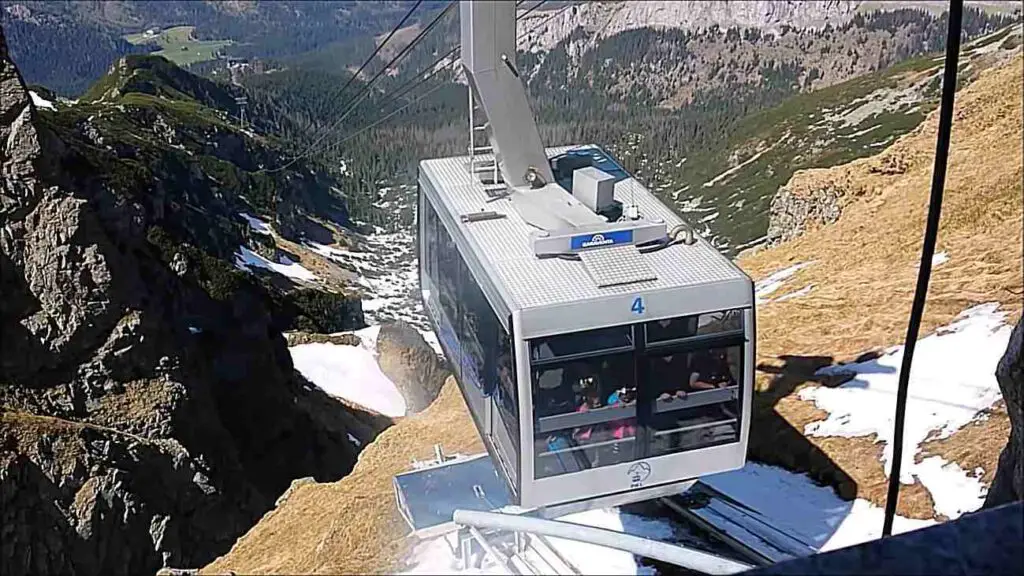
The Tatra Mountains are not only about high peaks exceeding 2,000 meters above sea level, but also smaller hills that are equally popular among tourists. One of the most famous peaks associated with the Tatra Mountains is Kasprowy Wierch. This hill, located in the Western Tatras, reaches a height of 1,987 m above sea level.
Positioned on the Polish-Slovak border, it is home to one of the most famous ski resorts in Poland bearing the same name. Three cable cars transport visitors to the summit, and it is also accessible via hiking trails. Kasprowy Wierch features two downhill ski trails, attracting numerous ski enthusiasts each year.
The unique landscape of the Tatra Mountains is also shaped by numerous passes. One of the most famous is Szpiglasowa Przełęcz. This wide pass, situated at an altitude of 2,110 m above sea level, can be reached by a well-known tourist trail from Morskie Oko Lake. Additionally, there is a route from the Valley of Five Polish Ponds to Szpiglasowa Przełęcz.
Szpiglasowa Przełęcz is considered one of the most beautiful viewpoints in the Tatras, offering stunning views of the Valley of Five Polish Ponds, the surrounding peaks, and the High Tatras. The highest mountain pass in the Tatras is Lodowa Przełęcz (2,372 m above sea level). Located in the main ridge of the Tatra Mountains, a green trail from the Valley of Five Ponds leads to it, open only during the tourist season.
References:
- https://www.koronygor.pl/knsgp
- http://www.peaklist.org/WWlists/euro600/poland/Poland_P100_height.pdf
- https://slovakia.travel/en/tatras-and-northern-spis