If you’re a hiking enthusiast like me, Rysy Peak should be on your bucket list. I was there and can share most important info you may find nowhere else. Why, you may ask? Well, Rysy isn’t just any old mountain. It’s the highest peak in the Tatra range from the Polish side and a hot spot for tourists from all corners of the world. But here’s something I bet you didn’t know – Rysy boasts not one, not two, but three summits!
The middle summit of Rysy in Tatra Mountains is standing tall at 2499 meters is the highest peak in Poland, while the other two are nestled on the Slovak side with the highest reaching 2501 meters, and the other at 2473 meters. If you want to know, the highest peak situated entirely in Poland is Kozi Wierch, a part of the famous Orla Perć range.
Your Hike to Rysy Peak in the Tatra Mountains
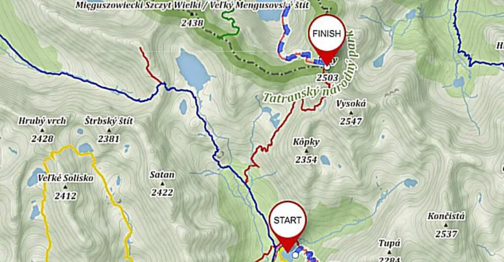
Trail: Palenica Białczańska – Morskie Oko – Czarny Staw – Bula pod Rysami – Rysy.
Duration for both ways: 11h 42 min, Distance: 24.9 km, Elevation: 1929 m
- The trail to Rysy might be a tough cookie, but it’s well worth it
- Did I mention, Rysy is the highest peak in Poland?
- Brace yourself for chains and exposure on your way up
- Always have travel insurance (just in case you tumble over to the Slovak side)
How Many People Make the Climb to Rysy? Which Path to Take?
The peak is accessible only by the red trail. So, I think when it comes to your plan to conquer Rysy, you’ve got two choices – either go Polish or go Slovak side. If you need a challenge, the Polish trail will test your mettle. It involves walking the famed asphalt road, waving hello to Morskie Oko, and then embarking on an uphill journey via Czarny Staw.
↳ Before you head to Tatra Park, I highly recommend reading my complete guide to Tatra Mountains. I showcase the most scenic places you won't want to miss. Make sure to check it out, so you don't overlook anything interesting: Tatra Mountains – An Insider’s Guide to All Attractions and Info
The Slovak trail, on the other hand, starts at the cozy Chata pod Rysami hostel. The Polish trail is no walk in the park – it’s technically more demanding with more chains and greater exposure. Plus, it boasts a considerably higher elevation. But if you’re not up for that, or if you’ve already trekked the Morskie Oko Rysy route, the Slovak trail is a good alternative.
Fun fact: Slovak side is also the fastest route to Rysy. And if you're out to conquer the Crown of the Polish Mountains, the rules don't specify which route you should take to Rysy.
The Trip to Rysy from the Slovak side is covered in the second part of this post.
Did you know there’s a third option for your adventure to Rysy? If you’re up for it, you can ascend from one side and descend from the other. Sounds exciting, doesn’t it? But, I believe this requires a bit more planning, especially when it comes to logistics.
Don’t worry though, I’ve done it myself and got you covered with some handy tips at the end of this post. But first, let’s break down the stats for each route:
1. Polish Trail: (here is my suggested accommodation which is closest to this trail)
Palenica Białczańska – Morskie Oko – Rysy + return:
- Duration: 11h 42 min
- Elevation: 1929 m
- Distance: 24.9 km
2. Slovak Trail: (here is my suggested accomodation that is closest possible to the trail)
Popradske Pleso – Chata pod Rysami – Rysy + return:
- Duration: 8h 40 min
- Elevation: 1449 m
- Distance: 18.9 km
3. Mixed Route (Poland – Rysy – Slovakia): For this option I suggest this accomodation and in the morning find a ride to Palenica Białczańska so after the hike, you are close to the hotel.
Palenica Białczańska – Rysy – Popradske Pleso:
- Duration: 10h 31 min
- Altitude gain: 1820 m
- Distance: 21.9 km
4. Mixed Route (Slovakia – Rysy – Poland) – For this option I suggest this accomodation and in the morning find a ride to Popradske Pleso so after the hike, you are close to the hotel.
Popradske Pleso – Rysy – Palenica Białczańska:
- Duration: 9h 51 min
- Elevation: 1558 m
- Distance: 21.9 km
The Trail to Rysy From Morskie Oko in Poland – A Breakdown
Route: Palenica Białczańska – Morskie Oko – Czarny Staw.
Time: 3h 15 min, Distance: 9.5 km, Elevation: 715 m
Here’s some useful info on reaching Morskie Oko (how to get there from Zakopane, where to park, and a trail description can be found by clicking the red text). Let’s keep it short for now. Expect to pay PLN 30 per day for parking at Palenica Białczańska.
Honestly, even off-season, you’re unlikely to be alone on the trail, but it’s worth to say that hitting the road early can help you dodge the crowd at the chains. Another perk of being an early bird? You’ll complete the trail quicker and have a good shot at avoiding any sudden weather changes.
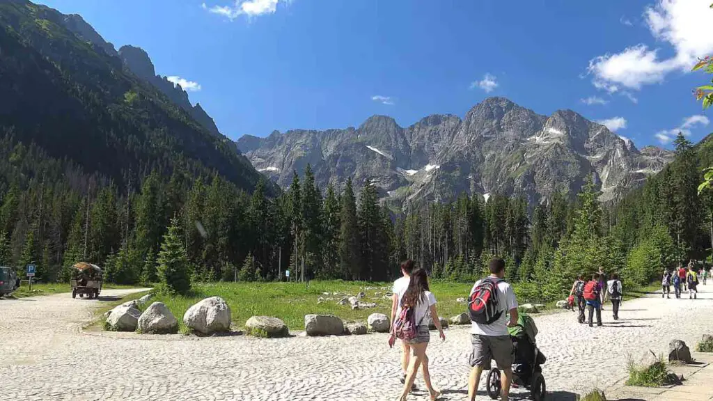
After all, mountain weather is usually friendlier in the morning than in the afternoon. The route to Morskie Oko is an 8 km asphalt road that you can conquer in a little over 2 hours. The red trail cuts through the asphalt serpentine four times, roughly in the middle of the road. Most folks cover this part while it’s still dark or just breaking dawn.
If you are beginner consider hiring local Tatra guide by clicking here.
If you’re thinking of overnighting at the Morskie Oko shelter, that’s a great idea! It’ll make your trek to Rysy significantly shorter. However, keep in mind that securing a spot at the hostel can be quite challenging. Alternatively you can stay in the closest possible location to the Palenica Bialczanska. This place is small village called Javorina in Slovakia – here is available accomodation.
If you do not care about the distance so much, then I suggest that you stay in Zakopane. Here are my top three picks across different price ranges in terms of accommodation in Zakopane:
- (€) Hotel Tatra: A brilliant, budget-friendly modern 3-star which is located in Zakopane, at an altitude of 1080 meters above sea level. It has indoor swimming pool, free Wi-Fi and classically furnished rooms with a beautiful view of the Tatra Mountains.
- (€) ❤️ Bachleda Residence Zakopane: A gorgeous hotel located less than 1 km from Aqua Park Zakopane. There is a bar and private parking on site. There is a restaurant in the facility. It offers air-conditioned luxurious rooms. Beautifull place!
- (€) Hotel Paryski Art&Business: This 4-star hotel has a seasonal outdoor swimming pool, free private parking, a garden and a shared lounge. It offers a restaurant, a terrace, an indoor swimming pool and a sauna.
To make the journey more manageable, I’ve split the trail from Morskie Oko to Rysy into three stages:
- Reaching Czarny Staw / Black Pond (1h)
- The demanding hike to Bula pod Rysami (2h)
- The final ascent to the Rysy Summit (1h)
In total, this takes about 4 hours, with the last stage mostly along a secured section.
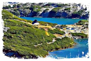
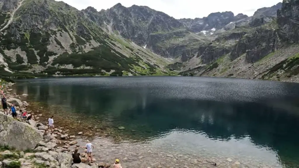
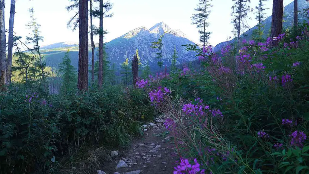
The trail to Rysy veers left around Morskie Oko. This stunning lake, with a depth of 54 meters, beautifully mirrors the surrounding peaks of Mięgusze and Mnich. The path quickly shifts into a steep climb, giving you a taste of the adventure that lies ahead.
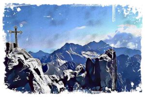
It winds by the Czarnostawski Waterfall up to the threshold of Czarny Staw (Black Pond). Here, a wooden cross and a breathtaking granite amphitheater welcome you. To the right, you’ll see the imposing Mięguszowiecka Kazalnica and its companions. There’s also a Smoking Waterfall. I can tell, this spot is perfect for a quick bite to refuel your energy.
Hiking From the Black Pond to Bula Near Rysy
Time: 2h, Distance: 2.1 km, Elevation: 551 m
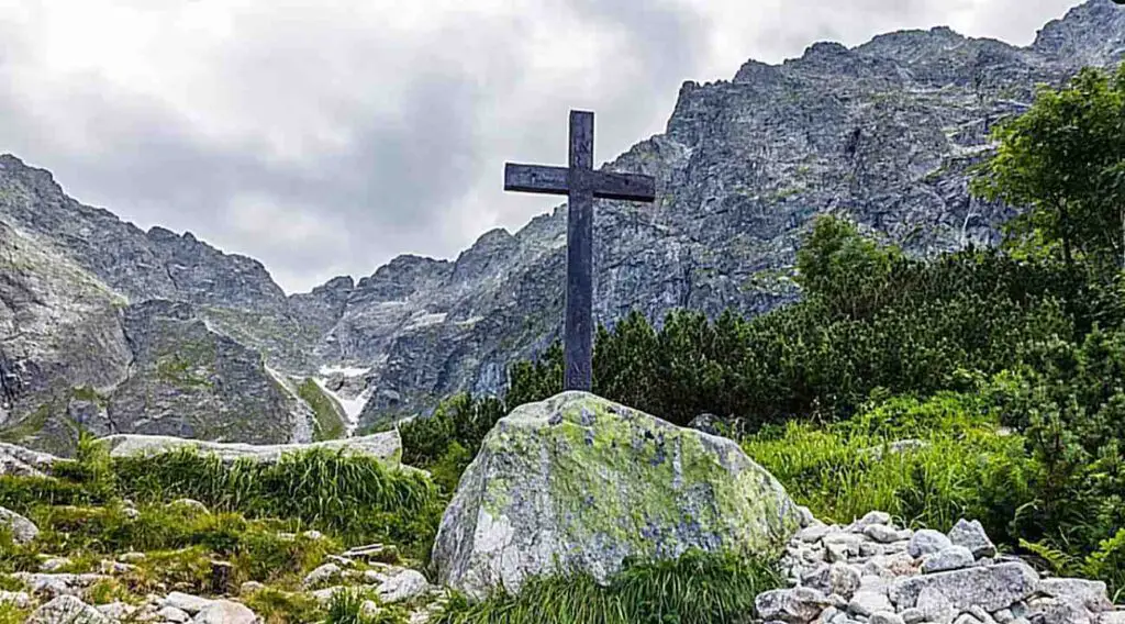
At the cross, you’ll encounter the final trail split of the day. The green markers veer right, pointing towards Mięguszowiecka Przełęcz pod Chłopkiem (a 2h 45 min climb). On the other hand, the red markers leading to Rysy swing in the opposite direction. From this spot, it’s about a 3 hour 20 minute trek to the summit. The trail initially meanders quietly around the pond on the left, then kicks into high gear with a steep climb.
You could say playtime’s over. Yes, it’s going to be tough, but technically it’s straightforward.
A rocky path leads to Bula, snaking through stone rubble. The scenery here is something else – you can really feel the raw power and majesty of the mountains. If you’re hiking early in the morning, before the sun’s had a chance to brighten the route, it might even feel a bit gloomy for some.
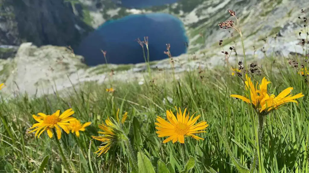
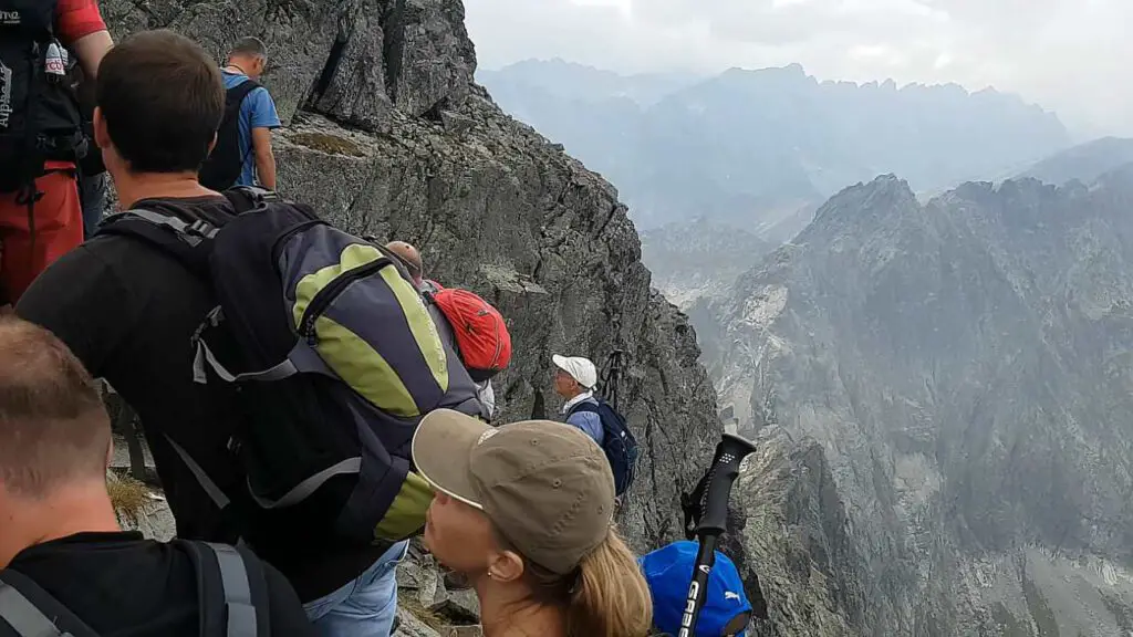
Roughly 1.5 hours from the cross, you’ll come across a masive boulder that offers a breathtaking panorama. This boulder sits on the Long Scree. The view of both ponds below is so mesmerizing that queues form not just for the chains on the trail.
Pretty much everyone waits their turn to snap a few shots for their photo album. Once you’ve captured the moment, you’re just a few bends and a straight stretch away from Bula pod Rysami – around 25 minutes, give or take.
If you need a snack, the area around Bula is an excellent spot. There’s a bit of flat land, the views are spectacular, and soon you’ll be walking alongside metal chains for support. Take a moment to appreciate Tomkowe Igły – these are distinctive sharp crags.
The flat part of Bula near Rysy is often used by TOPR as a helicopter landing pad during rescue operations in the area. Just bear in mind it’s noticeably chillier here than by the pond – altitude and shade make for a cool combo in this spot. And Bula pod Rysami is perched at a height of 2054 m.
The Final Ascent – Bula Near Rysy to Rysy Peak at 2499m
Time: 1h 19 min, Distance: 0.8 km, Elevation: 404 m
If you do not feel confident enough or you are beginner – please book local guide to assist you.
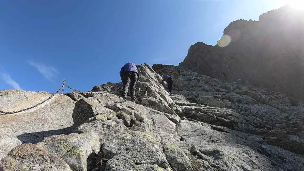
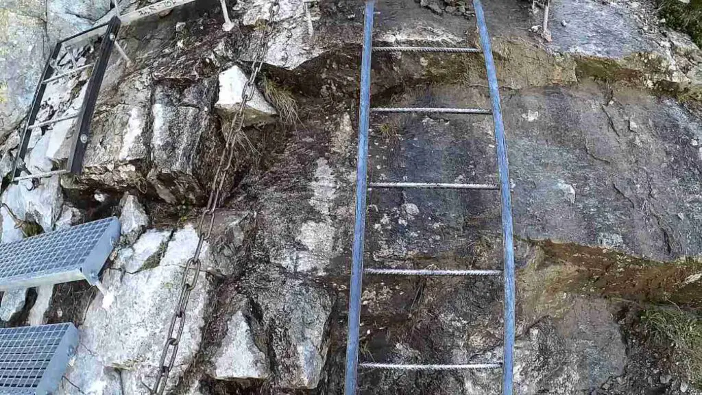
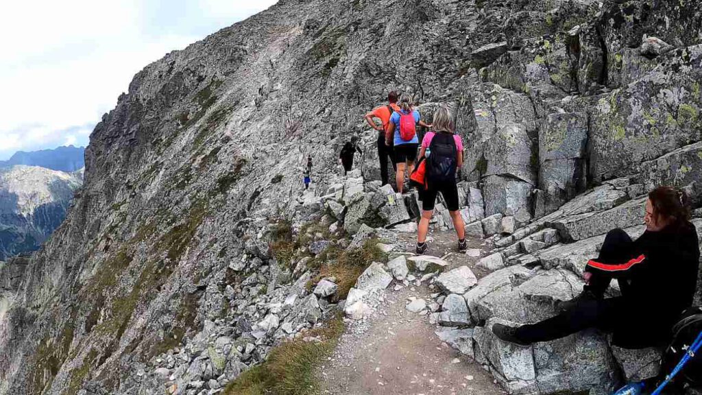
This is where the real adventure kicks in. Just past Bula, you’ll encounter the first set of chains that will accompany you nearly all the way to the top. The metal journey starts off gently, the heights aren’t too scary, and the chains rest easily on the rock formations. But it ramps up as you progress.
As you hold on to the chains, you’ll find yourself on a rocky ledge. To its right, you’ll see a large scratch – some mistakenly think this is where the peak gets its name. There’s no denying that the trail is well-equipped with safety chains – a whopping 360 meters of it
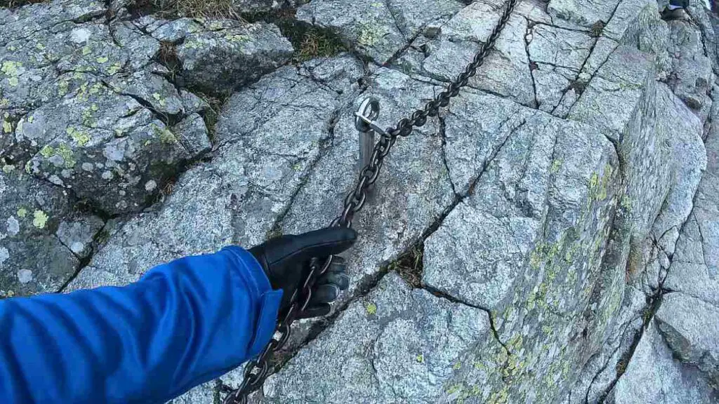
. These chains guide you over rocky blocks and smooth, slippery slabs. There will be several spots that require some climbing, and the views behind you will get your heart pumping. But don’t worry – there are plenty of spots where you can stop and catch your breath safely.
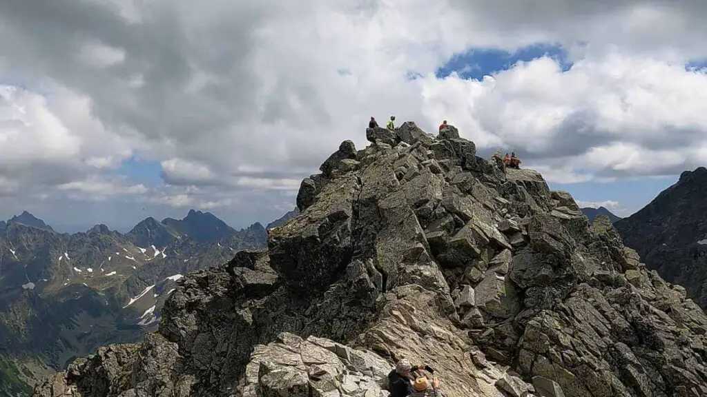
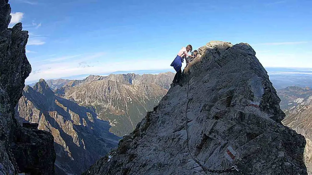
The safety chains end just short of the ridge, a few meters below the peak. This is where, in my opinion, the toughest part awaits. It’s a short, exposed, narrow traverse through the Pass under Rysy.
With several hundred meters of void on either side, the safety chains provide some much-needed reasurance. After you’ve navigated this section, a quick loop around the peak and you’ve made it:
Congratulations, you’re standing at the highest point in Poland!
It doesn’t get any higher than this! Rysy is a magnet for tourists, and over the years it’s been graced by the likes of Maria Skłodowska-Curie and her husband Piotr, and even Vladimir Ilyich Lenin. In fact, there’s a plaque at the peak commemorating Lenin’s visit, though it’s been repeatedly battered by the „restless winds” that whip through this area.
„Rysy” Means „Scratches”
Just past Bula, the trail rapidly ascends a rocky ridge, growing steeper, with a noticeable, long fissure on the right side. It’s here that the winter variant of the climb to the summit exists. You might come across the interpretation that the name of the peak originates from this fissure.
This, however, is only half the story – the name 'Rysy’ truly originates from the furrowed slopes of the entire massif, which includes Niżnie Rysy, Żabi Szczyt Wyżni, and Żabi Mnich. And there, the mystery of the name is resolved.
Is Rysy Summit Suitable for Beginners?
In my opinion, the technical challenges on dry rock and without snow are generally moderate. Yet, I don’t suggest this trail as your first experience with chain-assisted mountain hiking without local guide assistance. So, embarking on Rysy as a very beginner mountaineer might not be the best idea without assistance, however is doable.
- Before hitting the trail I encourage you to read this article first: Understanding the Risks – Tatra Mountains Death Statistics
↳ Book the guided hiking expedition to Rysy in Tatras by clicking here!
It’s advisable to first experience how you respond to exposure and how comfortable you are with the chains. Therefore, before attempting Rysy, I suggest trying out routes like Szpiglasowy Wierch from the side of the Valley of Five Ponds or Świnica.
Interestingly, despite the challenges that hikers face on the trail, Rysy is one of the most frequented peaks. Hence, there are probably a lot of queries from less experienced hikers: which is tougher, Rysy or Giewont? For me, there’s no doubt – Rysy is considerably more challenging, both physically and technically.
- If you are also considering hiking to Giewont Peak, then I suggest you read this fascinating article too.
However, if you’re accustomed to hiking and rock climbing with chains, we have good news – the trail to Rysy shouldn’t pose much of a problem. All of this, of course, assuming there’s no snow on the trail and the rock is dry.
But it’s worth noting that snow tends to linger here for quite some time, which heightens the risk of falling. So, be cautious and sensible. But under favorable conditions, for those who enjoy such trail bonuses, it’ll be a rewarding, albeit steep, hike.
A Brief History of the Trail Safety Chains
The history of the chains on this section dates back to 1886, when the first clamps were installed. Interestingly, the trail wasn’t marked until 12 years later. There are ordinary stretches between sequences of chains, so it’s not as if a constant vertical climb awaits you from Bula. In my opinion, the most dangerous aspect isn’t the difficulty of the trail itself, but the encounters with hikers moving in the opposite direction.
Other hazards on the trail include patches of frozen snow that persist until late spring and even into summer. Be mindful of the length of the day – in spring and autumn you’ll have considerably less time for the entire hike. Remember, a winter trip to Rysy is an entirely different ball game and is recommended only for experienced mountaineers.
At the very least, crampons and an ice axe will be necessary for such an expedition. To sum up – Are the 'Rysy’ difficult to scale? The trail is moderately challenging in the summer, but you should be aware of the risks and what you might encounter along the route.
Poland’s Highest Peak
While Rysy is the indisputable highest point in Poland for us, it holds a somewhat distant position in the Tatra hierarchy. The situation is slightly ameliorated when we consider only those peaks that have marked trails leading to them. In this case, Rysy takes a considerable lead as the highest peak in the Tatra Mountains.
Now, the most important part – if you want to fully claim the peak as conquered, you should extend your effort a little further to the Slovak side. Right ahead of you, more or less in a southerly direction, stands its meter-taller sibling. The distance isn’t great. You just need to traverse a small switchback (with significant exposure on the left) and clamber over large boulders to reach your destination.
This final stretch will likely take you about 2 minutes and then the summit is yours! The last, lowest peak is also located near our neighbors and is closest to the Waga Pass, boasting a height of 2,473 m.
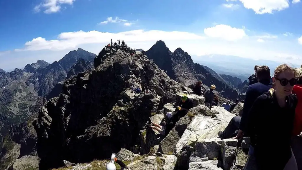
Panorama From the Rysy Summit
The thrill of reaching the summit is immense. And the entire experience is amplified by the views that literally take your breath away! It’s said that up to 100 peaks can be seen from here. I didn’t count, but you can undoubtedly spot all the highlights. After all, Rysy is situated at the heart of the Tatra Mountains.
You can see Ganek, Konczysta, and even the Tatra king and ruler, i.e., Gerlach. Koprowy and Krywań peeking from behind him are a beautiful sight. It’s also worth looking down towards the valleys: Cieszka, Mięguszowiecka, and the one you hiked through today, i.e., the Rybi Potok Valley. The still-undiscovered and highly recommended by me Belianske Tatras are also in sight.
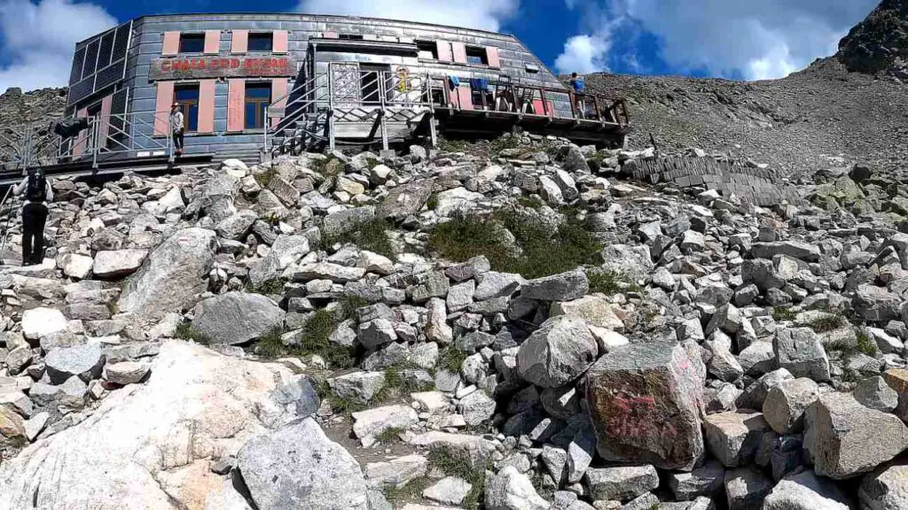
„Chata pod Rysami” Hostel and Shelter
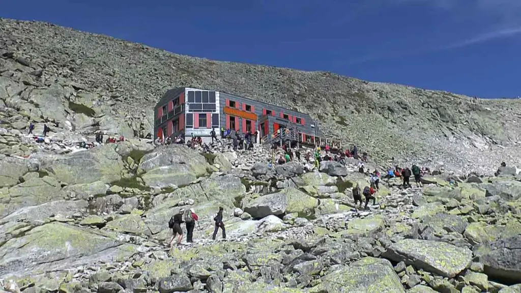
Descending from the summit to the Schronisko pod Rysami (Shelter under Rysy) and then climbing back up to Rysy takes an additional 80 minutes.
- Location of the Shelter / Hostel: Click Here
So, it’s 35 minutes down to the shelter and 45 minutes back up. If you feel up to the task, I highly recommend it. Just remember that descending to the Slovak side is only possible during the summer and autumn months – from June 16 to October 31.
You’ll have to account for an additional 270 meters of elevation gain in your trip. The trail from the summit to the shelter isn’t technically challenging or complicated. There are no safety chains here, and the views are simply magnificent! High appears particularly impressive from here.
The Schronisko pod Rysami is also often referred to as the Schronisko pod Wagą (Shelter under the Scale) due to the nearby pass under which it’s located. The shelter stands at an altitude of 2,250 m, in the upper part of the Żabia Mięguszowiecka Valley. Originally, even before the first shelter was built here in 1933, serious consideration was given to the construction of a large hostel.
↳ Check the closest accommodation to this hiking route by clicking here!
Fortunately, after protests from mountain lovers, the project was abandoned and a small shelter was built instead. Admittedly, the shelter has not had an easy life here. Many times in its history it was destroyed and devastated by avalanches, only to be painstakingly repaired.
Voices were raised suggesting that the shelter should be moved to a safer location. However, it was decided instead to significantly rebuild the shelter so that it could withstand future winter battles with avalanches. It’s worth emphasizing that there is no road leading to the shelter.
All supplies are brought in by so-called „carriers” or by ordinary tourists. For the latter, special parcels weighing up to 10 kg have been prepared. For their effort, each brave soul will be rewarded with tea and raspberry juice.
Interestingly, it’s not the shelter building that is the most recognizable structure in the area. That title goes to the toilet suspended over the abyss, which offers a delightful view! Especially considering that the front wall is made entirely of transparent organic glass.
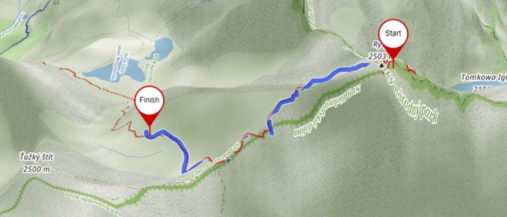
Return via Morskie Oko or Go To Slovakia?
According to the trails, descending from the top to Morskie Oko Lake will take you around 3 hours and 15 minutes. However, during the peak season, expect to add a bit more time due to the heavy trail traffic and queues at the chains. At the end of the descent, another 8 km of arguably charmless asphalt hike awaits you to reach the parking lot (around 1 hour and 50 minutes).
In total, you should allow about 5 hours from the summit to the parking lot. For this reason, many hikers find it more attractive to descend on the Slovak side, passing by the Chata pod Rysami shelter towards Popradskie Pleso.
I highly recommend this route. Just remember that due to Slovak restrictions, the trail is only open from June 16 to October 31. Here are some of our comments on this option.
Return via Slovakia – 3 Stages
If you’re considering this option, plan your logistics for returning from Rysy through Slovakia ahead of time. It’s not a decision to be made spontaneously at the summit. The descent from the peak to the nearest tram station (Popradské Pleso) takes about 4 hours.
Now the crucial part – in the Slovak transportation search engine you can check connections to Łysa Polana. Despite the relatively short distance, returning to the border by public transport can paradoxically be quite time-consuming. The journey is only 50 km, but it can take you about 2 hours.
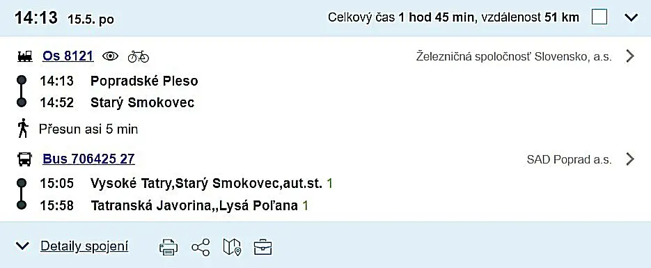
The journey should be broken down into three stages. First, you need to reach Stary Smokovec by elektricka, where after a 100 meter walk, you’ll arrive at the bus stop. From the train station, you’ll have to walk along the building, following the footpath in the opposite direction to the way you came.
You’ll soon arrive at a large square, largely used as a parking lot, from where buses to Łysa Polana depart. The ticket for the ride costs €2.3 and can be purchased from the driver. The Polish company Strama’s buses, which operate on the Zakopane – Poprad route, also stop here.
Once you reach the border, you’ll simply have to walk across the border bridge and, if you’re lucky, catch a bus to Palenica Białczańska. If there’s no bus in sight, you’ll have a 1.5 km walk ahead of you.
NOTE - you can only board the train if you've already bought tickets. The challenging part is that there are neither vending machines nor ticket counters at the station. I managed to buy tickets over the phone, although not on the first attempt, and the buying process took about 15 minutes. I can't speak to the situation at the previous station, but we believe there's an actual ticket office there. The fine for not having a ticket on the train is €50.
You can purchase tickets for the elektricka online – here.
„Safety First” When Climbing to Rysy
- Your physical fitness needs to be up to par, as the journey will likely take you around 12 hours, with a cumulative elevation gain of 1900 meters.
- Given that Rysy is a border peak, ensure you are covered by insurance for the Slovak Tatras.
- Don’t forget to pack warm clothing. The trail to Rysy passes through a quite shaded section, where snow tends to linger for a long time, even in the summer.
- The trail is quite popular, so to avoid overcrowding and queues at the chains, it’s advisable to start very early.
- Remember to carry headlamps during shorter days, as there’s a good chance you’ll be returning after dark.
- Rysy in winter offers a completely different experience. The trail is only recommended for seasoned hikers (crampons and ice axe are compulsory).
- Always check the weather forecasts – you can do so here .
Considering The Local Guide To Rysy Summit
You can find one on this website.
If you’re someone who loves a good adventure, let me say, the Tatra trails are an unbeatable experience. Especially when you’re hiking to Rysy, having a guide by your side is like having a safety net. You wouldn’t have to worry about straying off the path, and there’s a good chance you’ll stumble upon parts of the Tatras that would’ve been undiscovered territory, had you been alone.
Consider your guide as a storyteller, a person who breathes life into the scenic vistas around you. They spin tales about the mountains, the trails, the history, making your journey far more engaging. I am convinced, the journey becomes so much more interesting when you’ve got a personal narrator along the way, wouldn’t you agree?
Ensuring Safety with the Local Tatra Guide
If you’re a newbie to the world of hiking, it is worth to say, hiring a local Tatra guide to take you to Rysy is a smart choice. The guide ensures that you stay safe while you marvel at the beauty of the Tatra Mountains.
You see, these mountains can be unpredictable, and having an expert by your side gives you the confidence to embrace the adventure, while also making sure you’re safe and sound. So remember, when you’re there, you need to know that safety should always be a priority.
↳ Book adventurous Rysy Hiking Trip with Guide by clicking here!
Key Facts About Rysy Summit
How many peaks does Rysy have? It’s a tricky question, as there are three peaks. Two of them lie on the Slovak side, reaching heights of 2501 m and 2473 m respectively. The third peak, our Rysy, stands at 2499 m and is the highest peak in Poland.
Who first climbed Rysy? The first summer ascent was made by Eduard Blásy and his guide, Ján Ruman Driečny the Elder, on July 30, 1840. The first winter ascent of Rysy was carried out by Theodor Wundt and his guide Jakob Horvay on April 10, 1884.
Where does the name 'Rysy’ originate? It is believed to derive from the cracks seen on the walls of Niżni Rysy, Żabi Mnich, and Żabie Szczyt Wyżni.
The trail to Rysy was marked with red paint in 1898. Interestingly, metallic chains (safety measures) had been installed here 13 years earlier. As such, the official date of opening the route to Rysy is recognized as 1886.
- Regarding accidents and fatalities, it’s estimated that up to 100 people have lost their lives on the journey to the peak. This figure includes both routes (Slovak and Polish).
- You may also want to read this article: Mysterious Tragedy in the Tatras – The Unsolved Deaths in 1925
Although Rysy ranks as the 17th tallest peak in the Tatras, it’s the first one that the trail leads to. The panorama from the summit is truly stunning, purportedly offering views of up to 100 other peaks.
Practical Information
- Parking at Palenica Białczańska will cost you PLN 30 per day.
- You can learn more about buses and timetable from Zakopane – here.
- Remember, the descent to the Slovak side is only possible during summer (from June 16 to October 31).
- You can find a map of Rysy – here.
- Rysy stands tall at 2499 m (at least the Polish peak, hence, it is the highest mountain in Poland).
- For a detailed description of the trail to Morskie Oko, click here.
- Note that there is an entrance fee for the TPN (Tatra National Park) – you can find the price list here.
- Don’t forget to pack headlamps and warm clothing.
- It is crucial to check weather forecasts and purchase insurance (since this is a border route) before heading to the mountains. In Slovakia Rescue Team is Paid by you, unless you have insurance. In Poland it is covered by government.
- The trail to Rysy is technically challenging and is not recommended for those unfamiliar with using chains. It’s also quite strenuous, as the elevation gain from Morskie Oko is 1,100 meters.
Slovak Trail to Rysy – A Guide
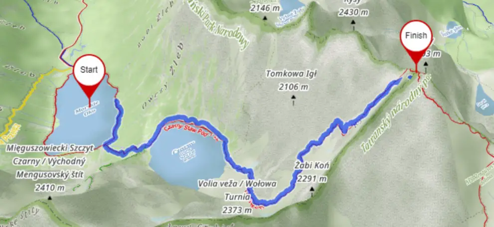
Route: Popradzki Pond – Mięguszowiecka Valley – Crossroads on Żabi Potok – Chata pod Rysami – Rysy. Return Time: 8h 40 min, Distance: 18.9 km, Elevation: 1409 m
- The trail to Rysy from the Slovak side is rated as moderately difficult.
- There are insured sections on this trail.
- The trail (Red) is open from June 16 to October 31.
- Remember to obtain insurance for the Slovak mountains.
Ascending Rysy from the Slovak side is a far simpler option than scaling it from the Polish side. Is it worth taking this route to the peak? Absolutely! Not only to experience the terrain on the other side of the border, but to also appreciate the captivating panoramas this trail offers.
Its popularity among the Slovakians is not without reason; the views provided here are arguably among the most splendid throughout the Tatras, especially along the marked trails. It’s no surprise, given that Rysy is nestled right in the heart of the mountains.
Challenges: Despite presenting less difficulty than its Polish counterpart, the trail’s significant elevation gain and the extended time spent on the trail should not be underestimated.
Even by Tatra standards, this trail can prove challenging. That said, the technical difficulties are largely confined to one section of chains and a system of footbridges. Provided the rock is dry, most hikers should be able to traverse this stretch without issue.
Time Requirements: It’s advisable to set aside roughly 10 to 11 hours for ascending Rysy from the Slovak side and way back, including logistics. While the trails indicate a total time of 8 hours and 40 minutes, one must account for rest breaks at the peak, meal breaks along the way, and of course, a visit to the renowned Tatra toilet.
On the return journey, consider a stop at Popradzkie Pond and take some time to ponder at the symbolic cemetery near Osterwa.
Traveling to Stary Smokovec from Zakopane
Journeying to the Rysy trail from the Slovak side can be quite time-consuming. It’s best to approach this in two stages. The first leg of the journey involves traveling from Zakopane’s center to Stary Smokovec in Slovakia. You can catch a coach operated by the Strama company – link below.
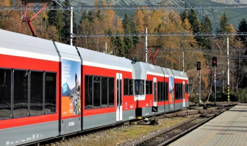
Tickets are priced at PLN 22. During peak season, it’s advisable to purchase tickets well in advance. The second leg involves switching from Stary Smokovec to a local train, known as the elektricka.
Ensure you have your ticket before boarding the train to avoid a potential fine I mentioned before. Tickets can be purchased at the ticket office, from a vending machine located in the station’s waiting room, or online. Depending on your preferred starting point, select your destination, either:
- Popradske Pleso
- Zastavka
- Strbske Pleso
It’s important to note that there are no ticket vendors or machines at the Popradske Pleso station for your return journey. It’s therefore a good idea to buy tickets in advance or via phone (the station has mobile coverage).
- Strama – timetable + tickets – here
- Elektrichka – online tickets – here
- Search engine for connections in Slovakia – here
If you’re driving, the journey from Zakopane takes approximately 1h 20 minutes. Both Štrbské Pleso and Popradzkie pond offer parking at a rate of €10 per day. If you arrive early, you can settle the parking fee upon your return from the trail.
The Easiest Trail to Rysy Peak
Time: 8h 40 min, Distance: 18.9 km, Elevation: 1409 m
As a starting point, you have three options to consider. All three paths eventually converge after about 1.5 hours of trekking at Popradskie Lake. You can kick-start your journey on the blue trail at the Popradske Pleso station (note – the station operates on request ). At the outset, a gentle 4 km asphalt path welcomes you. This path is utilized for transporting supplies to the shelter and also doubles as a cycle path.
Alternatively, if you arrive at the next station, Strbske Pleso , you’ll need to navigate a bit off the trail, heading towards the mountains for about fifteen minutes. This isn’t a challenging task. After crossing a distinctive viaduct, you’ll encounter a fork with red trails – take a right here.
Later, the green trail, which serves as a winter variant of the red trail, diverges from the main path but leads to the same destination. The red trail is closed in winter due to potential avalanche risks in the area.
I strongly recommend choosing the red trail here. All three route options present similar levels of difficulty, which is to say, none. Personally, we lean towards the first option as it is the shortest, leaving the other two for another time, perhaps when trekking to Koprowy Wierch.
Crossroads Above Poprad Pond To Shelter
Time: 2h 35 min, Distance: 4.5 km, Elevation: 816 m
From the crossroads, it’s a mere 5-minute walk to the hostel at Popradskie Pond. It’s certainly worth a visit, but preferably on your return from the peak. Now, the mountains beckon! The breathtakingly beautiful Mięguszowiecka Valley awaits.
In the morning, you’ll find prepared packages at the crossroads. These are supplies for the Rysy Shelter, carried up by hikers themselves. A hot cup of tea awaits them at the shelter.
After about 30 minutes, you’ll cross a bridge over Żabi Potok and immediately come to a trail fork. Turn left for Hińczowe Stawy and Koprowy Wierch, or right for Rysy. As you walk, you’ll be treated to the magnificent vista of the Baszt ridge (to your left), with the towering Mięguszowiecki Wołowiec straight ahead.
From here, the slope gradually steepens. You’ll first traverse dwarf mountain pine, winding trails, and then the landscape takes a much more dramatic turn. The Mięguszowieckie, Small and Great Ponds in Żabie look absolutely stunning.
Chains on the Trail to Rysy from the Slovak side
Under favorable conditions, the most challenging segment of the Rysy trail from the Slovak side poses no difficulties . However, things may be quite different with slippery rocks and ice. Nevertheless, we have mixed feelings about this.
It appears to us that the profusion and concentration of iron disrupt the aesthetics, leaving an unsightly impression and detracting from the natural harmony of the Tatra Mountains’ beauty. It seems these instalations were primarily designed for carriers delivering supplies to the shelter. Regardless, this is the only notably difficult spot on the route, beyond which you’ll need to simply maintain your stamina.
From Rysy Shelter To Rysy Peak
Time: 45 min, Distance: 0.8 km, Elevation: 258 m
As the trail passes through a Himalayan-style gateway, you enter a landscape of unparalleled beauty. Just before this, a plaque mounted on a rock welcomes you to the Free Kingdom of Rysy. Chata pod Rysami is a seasonal refuge open in the summer from June 16 to October 31.
The accommodation is somewhat limited, offering only a handful of spaces. Also, the network coverage isn’t particularly good, so it’s best to text the shelter for reservation purposes.
Staying here costs around €24 at weekends, and a few euros less during the week. The shelter has faced the wrath of avalanches on several occasions throughout its history, with the last renovation carried out in 2012.
The peak is just 45 minutes from the shelter, and while the trail is no longer technically challenging, it still offers captivating views. The scenery becomes particularly stunning from the pass—brrr ah! Below is Dolina Ciężka, Ganek and the renowned Galeria Gankowa, and then the magnificent Gerlach itself. After crossing the ridge, the view opens up to the Polish side with Mięguszami in the foreground!
And then it’s the final stretch to the peak, albeit a narrow one, so tread carefully to avoid slipping. Rysy comprises three peaks. The border peak stands at 2499 m, but in Slovakia, there’s an even higher peak at 2500 m, and the third, ranking last in hierarchy, stands at 2473 m.
Practical Information for the Slovak Side
– The trail is closed during winter
– Don’t forget to get insurance
– Entry to the TANAP region is free
– Parking costs €10 per day
– The Rysy trail from the Slovak side is much simpler than the one from Morskie Oko
– Before setting off for the mountains, ensure you’ve checked the return public transport options
References:
- https://pl.wikipedia.org/wiki/Rysy
- https://idos.idnes.cz/
- https://pl.wikipedia.org/wiki/Ni%C5%BCnie_Rysy
- https://www.zakopane.pl/strefa-turystyczna/turystyka/wycieczki-gorskie-latem/szlaki-lato/rysy/
- https://kgp.info.pl/wykaz-szczytow/rysy/
- https://topr.pl/