Let me say, the Slovaks have a gem in their mountains, and it’s called Great Rozsutec. They believe it’s the most beautiful peak in their country, second only to the Tatra Mountains’ Kryvan. I can tell you, there’s some truth to it. While it’s not the highest peak in the Fatra range, falling short by a hundred meters to Kriváň, it has become a captivating symbol of the Little Fatra. The peak itself is visually stunning, and if you make it to the top on a clear day, you’ll be rewarded with breathtaking views.

As you stand there, you’ll easily spot the prominent Chocz, Tatry, Low Tatras, sister Great Fatra, and even our Beskids. The journey to the top might be tiring, but it offers a whole range of experiences that you won’t find anywhere else in Poland. I believe the fact that the Slovak side is not far away makes it even more appealing.
If you want to explore Great Rozsutec, it’s essential to remember a few things. First, don’t forget about insurance when venturing into the Slovak mountains. Safety should always come first.
Simple Chains and Surprising Challenges

On the trail to Veľký Rozsutec, you’ll find chains to help you along the way. I am convinced that these chains make the climb relatively simple. Interestingly, Small Rozsutec is more difficult than Veľký Rozsutec, so be prepared for a challenge if you decide to tackle both peaks.
↳ Before you head to Tatra Park, I highly recommend reading my complete guide to Tatra Mountains. I showcase the most scenic places you won't want to miss. Make sure to check it out, so you don't overlook anything interesting: Tatra Mountains – An Insider’s Guide to All Attractions and Info
Choosing the Right Trail to Great Rozsutec
To fully enjoy Great Rozsutec, you need to be in good physical condition. Be prepared to conquer 1200 meters of elevation, encounter several chains, and explore the enchanting Dierys. But let me say, as you trek, you’ll find that the elevation gain seems almost enjoyable, and the hike is truly rewarding. First, decide where you want to start your loop and its direction. Here are two options for you:
Option 1 – Biely Potok and Hotel Diery
If you choose to start from Biely Potok, it’s best to use the parking lot at the Hotel Diery. The parking fee is €5 (2023). The blue trail begins here, and the entire route should take around 6 hours and 40 minutes. During this time, you’ll cover almost 15 km and climb a staggering 1161 m of elevation gain.
Option 2 – Stefanova
In this option, the car park is located in Stefanova. The parking fee is comparable to the first option. The advantage of starting from Stefanowa is the shorter trail, taking a total of 5 hours and 22 minutes to cover 10.7 km and gain 1000 m of elevation.
You can use the saved time and energy to explore Little Rozsutec. However, the downside is that you may miss Lower and New Diery. But after careful consideration, I think option two is worth it. The most captivating part of Dier is the section from Koliba to Podžiar. If you’re keen, you can add an hour-long loop to explore the missed part.
Deciding the Trail’s Direction
I believe it's best to go clockwise. Start with Diery, move on to Sedlo Medzirozsutce, reach the peak, descend to Sedlo Medziholie, and finally make your way down to Stefanowa.
Following this route offers a few advantages. Firstly, it’s easier to climb up the Dierys and ladders than to go down. Secondly, you’ll likely have more energy at the beginning of the trail, allowing you to truly appreciate the captivating route.
On the other hand, the trail from the pass to Stefanova isn’t particularly remarkable as it mostly passes through a forest. If it rains, the path can become quite muddy. But I think it’s the perfect route to end your trek.
Great Rozsutec from Stefanowa
Duration: 5h 22 min, Distance: 10.7 km, Elevation: 1000 m
Starting your journey from Stefanowa, you’ll reach Dier at the height of Koliba after around 40 minutes. Don’t worry about missing New and Lower Diery, because the most impressive and stunning section, Janosikowe Diery, is still ahead! This section, known as Upper Diery, begins just beyond Koliba. Here, you’ll find the most ladders and waterfalls, with the highest waterfall reaching a magnificent 4 meters. It’s truly wonderful!

Just remember to follow the blue trail until you reach the pass. It takes about two hours to complete the upper Diers, where sequences of ladders and footbridges make time fly.
As you walk, you’ll encounter the green trail twice, but you won’t need to follow it. The first green trail intersection appears after 45 minutes, signaling the end of the first insured section. The trail becomes more tranquil here, allowing you to catch your breath. After about 10 minutes, you’ll reach the second intersection with the green trail, where you should continue on the blue trail. More exciting experiences await you there.

In about 50 minutes, the forest starts to thin out, and you’ll emerge onto a lush green clearing. Your attention will quickly be drawn to the striking Maly Rozsutec!
If your primary interest was Diery, the green return trail branches off to the left at this point. But if you’re up for the challenge, continue your journey to fully experience the magic of Great Rozsutec.
A Detour – Little Rozsutec (Optional)
Duration: 35 min, Distance: 1.6 km, Elevation: 150m
At first glance, it might seem impossible to safely set foot on Little Rozsutec’s peak. The estimated 30-minute climb might sound unbelievable and too good to be true. As you start your ascent, you’ll probably check your watch and shake your head in disbelief. But I can tell you, the trail is indeed challenging. It’s considered the most difficult section in Mala Fatra, short but demanding.

You’ll first pass through a forest, then navigate rocky terrain. The chain sequence in this section requires some experience with „iron” and a good tolerance for exposure. But trust me, it’s worth it a hundred times over! The entire detour, there and back, takes about an hour, with a significant portion of that time spent capturing the incredible views in photos.
You may also want to read this article: Discover the Magic of Mala (Lesser) Fatra in the Tatra Mountains
From Medzirozsutce to Great Rozsutec and Medzicholie

Duration: 2h 22 min, Distance: 2.9km, Elevation: 409m
Medzirozsutce offers an amazing view of both Rozsutka and the surrounding mountain ranges. This stunning vista is a result of the intensive sheep grazing carried out in the area until the 1970s, which led to significant deforestation. It’s the perfect spot for a short picnic.
After taking a break, you’ll continue your trip on the red trail, which leads to the steepest climb of the adventure. But don’t worry, as the challenging ascent has its rewards – mountain pines start to appear, and the panorama expands before your eyes.
From this point on, the walk becomes much more enjoyable, albeit slower, as you’ll frequently stop to capture the incredible scenery in photos. You’ll also encounter the first chains on this part of the trail. Interestingly, even though Great Rozsutec is 300 meters higher than its sibling peak, reaching the summit is surprisingly easier.

The chains here are less intimidating and primarily serve as assistance on wet rocks, rather than being absolutely necessary. At the peak, you’ll find ample space to sit down, reflect, and take in the spectacular views.
The neighboring, domed Stoch and the S-shaped ridge extending toward Chleb are particularly impressive. Keep in mind that the trail to Veľký Rozsutec is closed from March 1 to June 15 to protect nesting birds in the area. The descent to Medzicholie is relatively quick, with a few extra ladders and a sequence of chains to help you navigate wet and slippery sections.
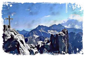
Although the descent might not be the most comfortable, the breathtaking scenery more than makes up for it. Once you reach the pass, only a 50-minute forest walk remains to reach Stefanowa. Be cautious during or after rain, as the path can become quite muddy and swampy. And remember, the first photo of this post captures the majestic Great Rozsutec from the trail leading to the neighboring Stoch peak, showcasing the mountain’s true splendor.
Medziholie Pass – An End to Your Trip
The name „Medziholie” pass roughly translates to „a place between the pastures„. It’s a nod to the time when sheep were actively grazed in Mala Fatra and pastures were known as „shepherd’s farms„. Two shelters once stood here but tragically burned down – first due to the Nazis, and then in 1985, a diesel engine failure caused a devastating fire. If you look carefully, you can still spot the remains of the foundations in the clearing. Although there are no benches or chairs in this area, the breathtaking views will surely make you forget about their absence.
As you take in the landscape, your gaze will be drawn to the majestic Rozsutec, the undisputed ruler of the area. It’s worth noting that the pass rises above three valleys:
- Nová Dolina (where the green trail leads from Stefanová)
- the valley of the Biela stream
- and the Bystrička Valley
Medziholie is a rare example of a keystone pass, making it a fitting and memorable endpoint for your journey before you head back to your car.
References:
- https://www.terchova.sk/navstevnik/turisticke-trasy/vystup-na-velky-rozsutec
- https://turisticky.sk/turistika/velky-rozsutec/
- https://sk.wikipedia.org/wiki/Ve%C4%BEk%C3%BD_Rozsutec


