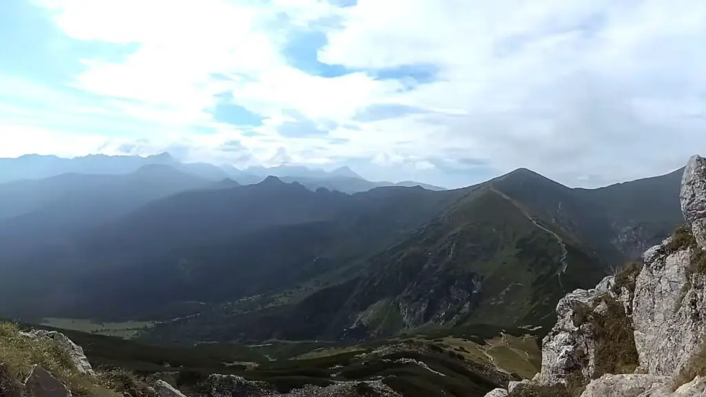
Giewont Peak, also known as the Sleeping Knight, is a popular hiking destination in the Tatra Mountains. Even though it’s not that high at only 1,894 meters, it offers amazing views from its rocky summit, crowned by a steel cross.

There are several routes to choose from, making the trip even more exciting. But let me say, despite its popularity, hiking Giewont can be dangerous, especially when the rocks are wet or during storms. The steel cross on the summit is a lightning magnet, so be cautious!
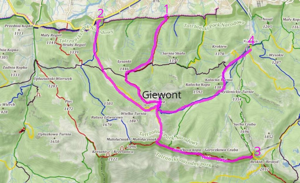
You can hike Giewont from the following starting points:
- Strążyska Valley (No. 1)
- Mała Łąka Valley (No. 2)
- Kasprowy Wierch (cable car entrance) (No. 3)
- Kuźnice via Hala Kondratowa (No. 4)
Now let’s dive into more details:
↳ Before you head to Tatra Park, I highly recommend reading my complete guide to Tatra Mountains. I showcase the most scenic places you won't want to miss. Make sure to check it out, so you don't overlook anything interesting: Tatra Mountains – An Insider’s Guide to All Attractions and Info
1. Trail Through Strążyska Valley and Grzybowiec Pass
Important: The Grzybowiec Pass route is closed from December 1 to May 15.
| GIEWONT | ASCENT | DESCENT | TOTAL |
| Sum of ascents | approx. 1020 m | approx. 10 m | approx. 1030 m |
| Route length | approx. 5.8 km | approx. 5.8 km | approx. 11.6 km |
| Time (the march itself) | approx. 3:30h | approx. 2:30h | approx 6:00h |
To start your hike from the Strążyska Valley, head to Zakopane at the end of Strążyska Street. You can catch a bus from the city center to get there. Once you arrive, you’ll pass through the Strążyska Glade and follow the red and black trails towards the Grzybowiec Pass. I think this part of the hike is really enjoyable as you walk along the stream and ascend through some forested bends.
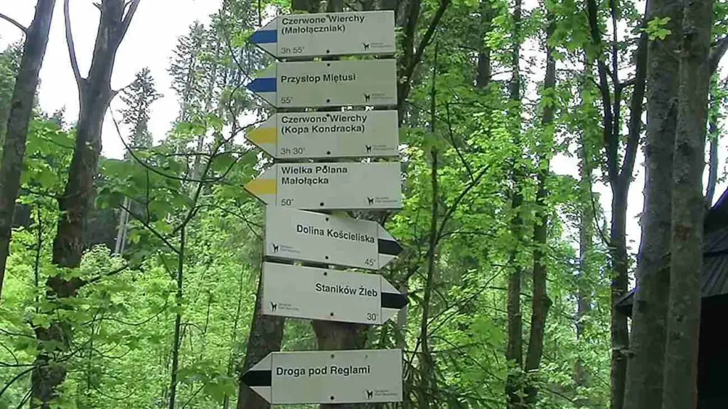
After about 1 hour and 30 minutes, you’ll reach a fork in the road. If you need a reference, the black „Droga nad Reglami” trail leads to the Mała Łąka Valley, while the red trail continues up to the Grzybowiec ridge. Being there, you need to know which path to follow based on your preferred route.
As you continue your journey, the view of the Great Turn (Wielka Turnia – 1,847 m) partially unfolds. Turning left, you’ll climb the ridge to a small clearing. From there, a short hike through the forest leads you to traverse the western slope of Maly Giewont (1,728 m). This narrow path crosses steep, grass-rock slopes that drop dramatically into the Mała Łąka Valley. I can tell you that the views are stunning, showcasing different sections of the valley and the towering Wielka Turnia on the other side.
If you encounter snow patches here, especially during spring, be extra cautious or even consider turning back. A slip could lead to a dangerous fall down the valley. The trail eventually takes you to a rock rib, sometimes mistakenly called „Szczerbinka„. Climbing this several-meter-high rock isn’t too difficult, but it does require using your hands.
Continuing along, you’ll cross the Żleb Pod Progiem and begin a steep ascent along the rock walls of the perch descending from the Wysoka Giewoncka Baszta. The stone path leads straight up to a flat pass above. Crossing the Sleeping Knights’ Gulch on a grassy slope, you’ll then ascend to the Siodlo Pass (1,630 m), nestled between Maly Giewont (1,728 m) and Siodłowa Turnia (1,647 m).
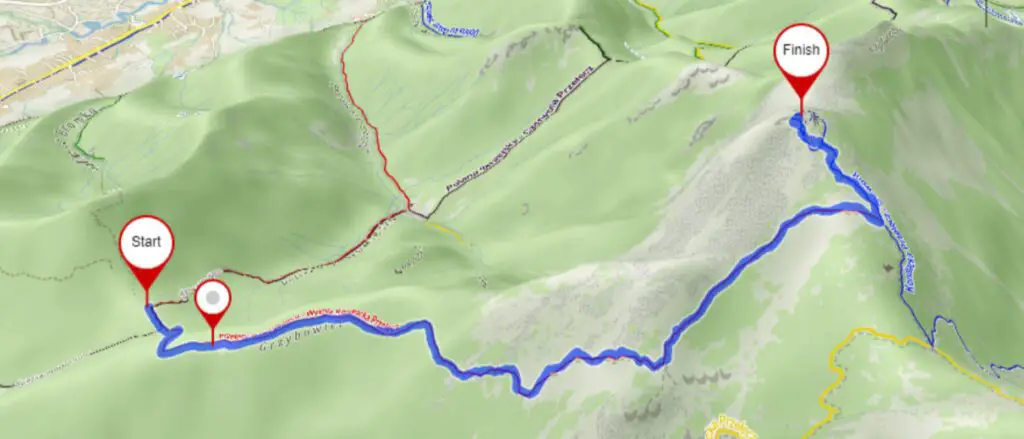
At Siodlo Pass, take a break to soak in the facinating view of the Mała Łąka Valley below. The cross on top of Giewont is already visible from here. The trail continues through dwarf pine trees and grassy slopes up to the Kondracka Pass (1,765 m), where it meets the blue trail from Hala Kondratowa.
For details on reaching the summit, refer to the description after fourth variants of approaching Giewont via Wyżnia Kondracka Pass which is described below the page.
2. Hike Through Mała Łąka Valley
| GIEWONT | ASCENT | DESCENT | TOTAL |
| Sum of ascents | approx. 960 m | approx. 10 m | approx. 970 m |
| Route length | approx. 5.9 km | approx. 5.8 km | approx. 11.7 km |
| Time (march itself) | approx. 3:20 h | approx. 2:30 h | approx. 5:50 h |
Start your adventure from the Gronik estate, located on the road from Zakopane to Kir and Chocholow. You can get there by bus from the center of Zakopane.
After passing the glade, the yellow trail takes you through the forest and into areas with lower vegetation. As you hike, the terrain flattens out at a spot called Wyżnie, before the trail steepens again, leading you to the edge of the Niżna Świstówka. A sharp ascent takes you through a section of the Głazisty Żleb (watch out for avalanche risks) and past the constriction between Siodłowa Turnia on the left and the Mnichowe Turnie (Grandfather, Grandmother, Monk) on the right.
Leaving the żleb behind, you’ll traverse to the left and continue through fields of blackbirds until you reach Kondracka Pass (1,725 m)—about 2 hours and 40 minutes from the entrance to the Mała Łąka Valley. Here, several trails intersect:
- The yellow trail leads up to Kopa Kondracka (2,004 m) on the right.
- The blue trail goes straight down to Hala Kondracka.
- The blue trail continues left along the ridge to Wyżnia Kondraka Przełęcz (1,765 m) and on to Giewont.
Take a left turn and within a few minutes, you’ll arrive at Wyżnia Kondracka Przełęcz (1,765 m). For further details on reaching the summit, refer to the description after last point down below.
3. From Kasprowy Wierch via Kopa Kondracka (2,004 m)
| GIEWONT | ASCENT | DESCENT | TOGETHER |
| Sum of ascents | approx. 570 m | approx. 10 m | approx. 580 m |
| Route length | approx. 6.1 km | approx. 5.8 km | approx. 11.9 km |
| Time (march itself) | approx.. 3:10 h | approx. 2:30 h | approx. 5:40 h |
During the season, the Kasprowy Wierch cable car is quite popular with tourists, so it’s a good idea to buy a ticket with a reserved departure time. You can find all the necesary information here:
After exiting the upper cable car station on Kasprowy Wierch, turn right towards the summit and climb the stone stairs to the meteorological observatory and beyond to the very top (1,987 m). Here, you’ll encounter the green trail from Kuznice, which takes about 3 hours to climb on foot.
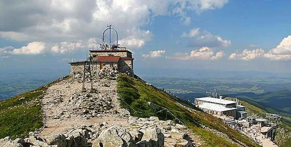
At the top, there’s a bell that used to help guide hikers to the summit in poor visibility.
Hiking Along the Ridge
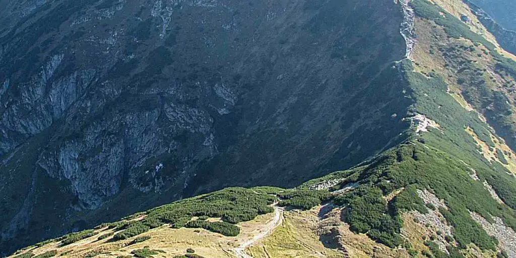
Continue westward on the red trail, with a path encircling the top of Kasprowy Wierch joining from the left, from Sucha Przełęcz. The path follows the ridge along the Polish-Slovakian border, first descending to Goryczkowa Przełęcz nad Zakosy (1,816 m), and then traversing the southern slopes of Middle Goryczkowy Wierch (1,874 m) to reach Goryczkowa Przełęcz Świńska (1,801 m). As you advance along the ridge, you’ll be treated to stunning views of the Cicha Dolina. The path bypasses the summit of Goryczkowa Czuba (1,913 m) on the south side and continues through Suchy Wierch Kondracki (1,890 m), descending on the north side of the ridge to Przełęcz pod Kopą Kondracą.
At this point, the green trail to Hala Kondratowa converges on the right, but you should continue along the ridge following the red signs. From the pass, it takes about 20 minutes to climb to the top of Kopa Kondracka along a wide, well-trodden path (approximately 1 hour and 55 minutes from Kasprowy Wierch).
The Scenic Hike From Kopa Kondracka
The name Kopa Kondracka („kopa” translates to „pile of earth”) perfectly captures the shape of the peak. Furthermore, it is surrounded on three sides by „shortcut” paths trodden by tourists skirting the summit.
As the lowest of the Red Peaks massif (Czerwone Wierchy), Kopa Kondracka offers breathtaking views, especially of the Cicha Valley and the rocky outcrops of the southern slopes of Krzesanica (2,122 m) descending to it, as well as the Giewont ridge seen „from behind” in relation to the popular view from Zakopane. From the top, you can see the network of paths (trails) on Kondracka Pass.
Descending to Kondracka Pass
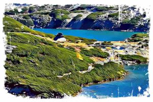
Leaving the red trail that continues along the Czerwone Wierchy (Red Peaks) ridge, we descend north along the yellow trail to Kondracka Pass. In summer, with good weather, this section feels like a leisurely stroll, but in poor visibility and icy conditions, it becomes very dangerous. The western slopes of the ridge descend to Vyšné Svistovka (the highest part of the Mała Łąka Valley). There are numerous cave openings here, including the system of the Great Snowy Cave, the longest in Poland and the deepest in the Tatra Mountains. In less than 40 minutes, you’ll descend to Kondracka Przełęcz (1,725 m) and further to Kondracka Przełęcz.
For further description of reaching the summit, refer to the fourth variants below.
The Trip from Kuźnice via Hala Kondratowa
This is likely the easiest way to ascend Giewont, and I recommend it for the descent, so I describe it below as the return from the summit.
| GIEWONT | ENTRY | DESCENT | TOGETHER |
| Sum of ascents | approx. 900 m | approx. 10 m | approx. 910 m |
| Route length | approx. 5.8 km | approx. 5.8 km | approx. 11.6 km |
| Time (march itself) | approx. 3:15h | approx. 2:30h | approx. 5:45h |
On the ridge from Kondracka Przełęcz in the direction of Giewont, there are fenced areas prepared on the flat and wide ridge where you can rest without damaging the sparse vegetation. In summer, when the weather is nice, it can be so crowded here that you have to wait in line to enter Giewont.
The Climb to Giewont’s Summit
Expect the ascent to take about 40 minutes (as long as you don’t have to wait in line).
From Higher Kondracka Pass, you’ll face a short climb along the path before encountering the most challenging part of the journey. The road forks, with one-way traffic organized – the right side is for ascending. The climb to the summit follows a series of rock shelves and bends, which are very well protected by chains.
In some places, comfortable steps are cut into the rock. The path is not very exposed, but the most significant danger comes from multiple people using the same section of the chain at once. The rock here is very slippery, even polished in places, and can be hazardous in wet or icy conditions. When planning your trip, keep in mind that you may need much more time for a section that could typically be covered in 20 minutes, due to the queue of eager climbers.
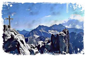
At the peak of Giewont, a 15-meter high steel cross stands, which was erected in 1901. In addition to its obvious symbolic nature, this cross poses a danger during lightning storms. There is limited space around the cross, and caution must be exercised as the walls on the north side, towards Zakopane, drop down a 600-meter precipice.
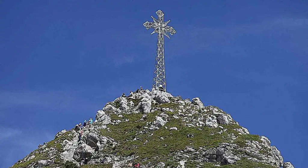
The Giewont massif is made up of: Small Giewont (1,728 m), Great Giewont (1,895 m), where the cross stands, and Long Giewont (1,867 m), which forms a ridge about 1,300 meters long.
Interesting facts about Giewont:
The name Giewont originates from various sources. Some attribute it to the surname of a highlander – the Giewont family. Others believe it comes from the German language, from the word Wand – wall, rock. The original form may have been Gewand – a group of rocks, or Gähwand – „steep rock”.
The Giewont Cross is a destination for religious pilgrimages – on August 19 (the anniversary of the erection of the cross) and September 14 (the Feast of the Exaltation of the Holy Cross).
Accidents on Giewont are most commonly caused by:
- Lightning strikes (during thunderstorms, the cross attracts lightning). The most severe incident occurred on August 22, 2019, when four people, including two children, died, and more than 150 people were injured. In 1937, lightning strikes claimed the lives of four people and injured 13 others.
- Falls from heights – these accidents happen when hikers, unaware of the danger, attempt to climb to or from the summit from the north. The rock walls here have a relative height of about 600 meters. Kirkor Canyon is infamous for accidents.
- Suicides – Giewont is the second most popular peak chosen by those intending to commit suicide, with Nosal being the first.
Legends associated with Giewont include the tale of sleeping knights under Giewont, who served King Chrobry. These knights are said to awaken when Poland faces great danger, with the rallying cry „It’s time!”. The legend is connected to the numerous caves found within the masif, including the Sleeping Knights Cave and the Sleeping Knights Higher Cave.
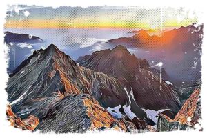
From the summit, you can enjoy an expansive panorama of the Tatras. To the east, you’ll see the Voloshin Ridge, Orla Perć with Granat and Kozi Wierch, Swinica, and Rysy behind it. Further to the south, there’s the Hruby Ridge and Krywań, with the surroundings of Kondratowa Valley closer to us. Toward the west, the Czerwone Wierchy Mountains and the West Tatra Mountains extend up to the Salatin Mountains.
Closer still, we can see the walls of Wielka Turnia descending into the Mała Łąka Valley. To the north, all of Zakopane and Podhale appear within easy reach. With good visibility, you can also see Pilsko, Babia Góra, and the Gorce range.
From the cross, the way back leads westward (with a signpost on the cross). First, you’ll navigate a rock with a chain, then a grassy-rock steep slope, and further down a rock depression with the help of chains until you reach the path.
Descent from Kondracka Przełęcz to Kuźnice via Hala Kondratowa
At Kondracka Przełęcza, turn left and continue following the blue signs to descend into the Dolina Małego Szerokiego, which is the upper part of the Kondratowa Valley. With a few hairpin turns through fields of blackbirds, you’ll reach the bottom of the valley. On the right slope, there is a basin named Piekło or Piekiełko.
The path descends, and you’ll enter the Kondratowa Valley. The path leads along the left side of the Kondratowa Glade directly to the hostel. PTTK’s Shelter on Hala Kondratowa (1333 m) is the smallest in the Polish Tatras, offering 20 beds. It’s an excellent place to rest and enjoy a meal after the challenges of climbing Giewont.
From the hostel, the path leads through the forest to Kalatówki Glade (to the left is access to the PTTK Kalatówki Mountain Hotel).
To the right, you can hear the sound of the Bystra Water Spout (one of the largest underground water outflows in the Tatra Mountains, unfortunately inaccessible to tourists). Pass the right edge of the clearing and descend directly to the rocky road leading from the hotel to Kuznice.
Now we pass the Albertine Monastery and the Brother Albert’s Hermitage. Slightly lower, the yellow trail leading to the Albertine Monastery on Sleepy Mountain (20 minutes) diverges to the left. Counting from the hostel, in 50 minutes we descend to Kuznice. From there, you can take buses or walk to the center of Zakopane.
References:
- https://pl.wikipedia.org/wiki/Giewont
- https://zakopaneapartamentylux.pl/blog/wyprawa-w-gory-szlaki-na-giewont-23